


Software, tools for the architect - trends 2025
As an architect, you know very well how valuable time is. Every minute spent searching for data is a waste that could be invested in creative design. Fortunately, the era of laborious information gathering is coming to an end!
With Ongeo.co.uk's Land Report service, access to comprehensive, precise and up-to-date spatial data becomes simple and automatic.
Discover how this advanced technology can revolutionize your workbench.
No more time-consuming data searches
Traditionally, the architectural design process requires tedious data acquisition from various sources such as public institutions, private companies, satellite systems or manual field measurements. From land and building records to utility information to zoning plans, each project is a separate information-seeking expedition. The data differs in structure, format, accuracy and acquisition time, their integration into a unified database can be a challenge. It's not only time-consuming, but also prone to errors and outdated data.
Access to key data is sometimes limited, and difficulties in obtaining it can lead to project delays. In addition, any error in information processing can significantly affect the final outcome of the work. The need to use up-to-date and accurate field data further complicates the entire process. Do we really need to be experts in everything instead of focusing on design?
Solution: CAD/GIS source data from
OnGeo.pl
Ongeo.pl provides a Terrain Report service. The report is a readable.pdf document that you can obtain for any plot of land in Poland. It contains more than 60 pages of information about the selected plot or area in the form of maps and summaries. The report generation time is only 5 minutes.
In addition to the.pdf document, you can also acquire specialized data - source data in CAD/GIS formats.

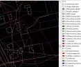
CAD/GIS source data in OnGeo.pl
© OnGeo.pl
These are ready-to-use resources that you can import directly into your design software (AutoCAD, QGIS, etc.).
What Does the Data Package Contain?
Vector data (up to 50 thematic layers).
-
In *.DWG and *.DXF format (dedicated to CAD software, such as AutoCAD),
-
in *gpkg format (dedicated to GIS type software, e.g. QGIS).

DXF vector database in QCAD software
© OnGeo.pl
The database contains the most important data in vector formats:
-
EGiB parcel boundaries,
-
Buildings,
-
MPZP - coverage and designation,
-
Building permits (polygon, lines, points),
-
Protected areas,
-
Natural monuments,
-
Historic properties (polygon, point),
-
Architectural preservation areas (polygon, point),
-
Cemeteries,
-
Zones from wind turbines,
-
Closed areas,
-
Airport impact zones,
-
Roads,
-
Planned roads,
-
Power lines,
-
Facilities related to the power grid,
-
Fiber optic cable,
-
Land cover,
-
Flood risks,
-
Landslides,
-
Nuisance facilities (training ground, line, point),
-
POIs,
-
Access and travel time ranges.
Graphics in PNG format. The folder contains rasters at a scale of 1:1000, including:
-
OnGeo.pl base map with the location of the property,
-
orthophotomap,
-
land development map,
-
map with classification contours and land uses,
-
scan of the local land use plan (if the plot is located in an area covered by mpzp),
-
NMT visualization in the form of shading.

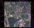
Imported orthophotomap in QCAD software
© OnGeo.pl
Graphics in TIF format. The folder contains rasters at a scale of 1:1000 including:
-
NMT numerical terrain model,
-
NMPT land cover map,
-
terrain exposure,
-
map with soil fertility,
-
raster with insolation of the area,
-
map of areas at risk of water stagnation.
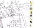
See what a sample Terrain Report looks like. Download the CAD/GIS source data using the "Download Package" button.
Check the data for free: https://ongeo.pl/raporty/przykladowy-raport/

Portal OnGeo.pl
© OnGeo.pl
What will the data be useful for?
Start by analyzing the urban context, using base maps to locate the parcel and understand its surroundings.
Before you make the first dash, using a scan of the Local Development Plan will make sure that your project is consistent with it.
Then, with an orthophoto, visualize the actual development by assessing shading, analyzing views from the proposed building and identifying potential collisions.
Take into account the existing utility network with the appropriate layer in the design.
Visualization of NMT in the form of shading will allow you to intuitively understand landforms, identify slopes and elevations, which will be helpful in analyzing rainwater runoff.
You gain access to a broad spectrum of terrain information, which is essential for making informed design decisions, minimizing risks, optimizing costs and creating sustainable and functional buildings.
Benefits for you: All information about the plot - verified and up-to-date!
-
Saves time - No more hours of web searches and visits to authorities. The report is generated in just 5 minutes.
-
Up-to-datedata - comes from more than 100 reliable sources that are continuously updated. Mistakes cost money - with OnGeo.co.uk you are sure to avoid costly mistakes.
-
Comprehensiveness - All the data you need in one place, in a ready-to-use format.
-
Reduced risk of errors - Avoid problems resulting from incomplete or outdated data.
-
Improved design quality: Make design decisions based on a complete picture of the site.

Site Report - Plot diagnosis
© OnGeo.pl
How It Works.
-
Select an area: Point out the area you are interested in on the OnGeo.pl map.
-
Specify the scope of the data: Choose what information you want to include in the Site Report and data package (e.g. records, utilities, plans).
-
Download the package: Generate and download the data package in CAD/GIS format.
-
Import into software: Import the data into your favorite design program and start working.
Example Applications:
-
Plot Analysis: Quickly verify development possibilities, taking into account the plot's development plan and utilities.
-
Conceptual design: Create preliminary concepts based on accurate site data.
-
Construction design: Development of project documentation taking into account all legal and technical requirements.
-
Inventory: Creating inventories of existing development and land and building records.
-
3D visualization: Creating realistic visualizations of projects taking into account the terrain.
CAD/GIS source data from OnGeo.co.uk is an invaluable tool for any architect and designer who values their time and strives to create the highest quality projects.
With automatic access to comprehensive and up-to-date spatial data, you can focus on what matters most - creative design and realizing your vision.
Check out the Sample Land Report today and see how much you can gain!
How to download plot information? | Instructions for generating a Terrain Report in OnGeo.pl portal .